DESTINATION ISLAND OF THE STATES

DESTINATION ISLAND OF THE STATES

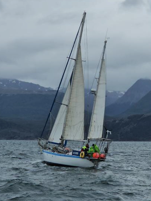
Sailing on the Ksar Sailboat to Destination Island of the States!

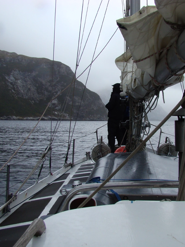
Embark on a memorable journey and expedition to the most remote island in the southern tip of the American continent, the Island of the States, with the Ksar Sailboat on its voyages through the Beagle Channel in Ushuaia and open waters. Discover how to explore this wild and enigmatic island in Argentina. During this trip, you will have the opportunity to discover amazing places such as the authentic lighthouse at the end of the world, where Jules Verne found inspiration for his novel, and Puerto Parry, a stable population of just four people, where you can marvel at the incomparable natural beauty of this unique destination in the world.

SAILING TO ISLAND OF THE STATES

Explore Tierra del Fuego with Ksar Sailboat. The most comfortable sailboat for sailing to Island of the States.

Embark on an exciting journey to the remote Island of the States in Ushuaia, Tierra del Fuego, aboard the Ksar Sailboat, sailing the waters of the Beagle Channel at the edge of the world. Discover the imposing natural beauty of the Tierra del Fuego region and experience memorable moments on the high seas. Join our maritime expedition and explore the pristine beauty of this remote destination with our personalized and exclusive service. We welcome you to a unique experience at the southern tip of Argentine Patagonia.

Discover Sailing to the Majestic Isla de Los Estados with the Ksar Sailboat Embark on an unforgettable voyage to the Isla de Los Estados with the Ksar Sailboat in Tierra del Fuego. Departing from Ushuaia, this journey takes you to a remote and pristine destination, offering a unique experience in Patagonia, Argentina. Explore the unspoiled nature and stunning landscapes of this extraordinary place. The Reserva Provincial Isla de Los Estados is part of the Provincial System of Protected Areas in Tierra del Fuego. Located to the east of the Fuegian archipelago, between 63° 45' and 65° West Longitude and 54° 35' and 55° South Latitude, it is separated from the Mitre Peninsula by the Le Maire Strait, approximately 16 nautical miles wide. This reserve encompasses the main island, the Año Nuevo Archipelago, and several smaller islands and islets, covering a total area of 50,736 hectares. The island's topography is diverse, featuring the final ranges of the Fuegian Cordillera. The highest peak is Mount Bove, standing at 823 meters above sea level. The coastlines are rugged, with numerous cliffs, deep fjords, inlets, and bays, abundant in vegetation and wildlife. The island is home to a variety of species, including Magellanic and yellow-eyed penguins, sea lions, huillines (otters), red deer, introduced goats, elephant seals, and giant petrels on Año Nuevo Island. It also hosts hundreds of marine and terrestrial bird species. Historically, the island served as a refuge for navigators reaching these latitudes and was the last protected haven for those heading to Antarctica. In 1884, a lighthouse was erected at Punta Lasserre, which still stands today as a replica of the famous San Juan de Salvamento Lighthouse, also known as the Lighthouse at the End of the World, popularized by Jules Verne's novel. Puerto Cook once housed a prison, which was closed in 1902 after a mass escape attempt. Remnants of the prison's facilities can still be seen. The island was frequented by seal hunters and fishermen during the 19th and 20th centuries, with remnants of their activities found in various bays and inlets. Today, the Reserva Provincial Isla de Los Estados is inhabited by naval personnel from the Apostadero Piedrabuena, based in Puerto Parry, the only permanent settlement with four residents. Experience Isla de Los Estados on this sailboat expedition through Tierra del Fuego. This destination, one of the purest places on the planet with a rich naval history, offers a 350-nautical-mile magical journey. Navigate the Beagle Channel to Puerto Español in Bahía Aguirre, waiting for favorable weather and currents to cross the challenging Le Maire Strait, reaching Isla de Los Estados. Conservation Value The Reserva Provincial Isla de Los Estados, or Chuanisin—"land of abundance," as named by the indigenous peoples—is highly valued for its unique and lush nature. It also holds significant importance for Argentina's history, Antarctic exploration, and the development of navigation and settlement in the South Atlantic. Its protected status and the special value assigned to it by the Provincial Constitution (Article 54º) declare it a "Provincial Ecological, Historical, and Tourist Reserve," a permanent heritage of all Fuegians. The conservation value of the reserve is based on its ecological and historical heritage. It is the only place in Argentina with fjords and along with the coastlines of Isla Grande de Tierra del Fuego, features unique coastal forest formations. The coastal avifauna is particularly notable, with the largest colonies of yellow-eyed penguins and southern giant petrels in Argentina. The reserve also hosts critically endangered species like the huillín and chuchungo, as well as endemic plant species. What It Offers Currently, the reserve's infrastructure includes a permanent coast guard station in Puerto Parry and a temporary station in Isla Observatorio during the summer. The use of natural resources is restricted to scientific research and regulated tourism. Description The reserve covers 50,736 hectares, including Isla de Los Estados and nearby islands and islets. Isla de Los Estados is 63 km long and at its narrowest point, 500 meters wide, featuring a mountainous relief. The coastlines are highly irregular, forming numerous fjords. The climate is cold, oceanic, and very humid, with annual precipitation near 2,000 mm and prevailing winds from the northwest and southwest. Vegetation includes evergreen forests of ñire and canelo, dense undergrowth of ferns, lichens, and mosses, and coastal grasses. The marine coast is characterized by extensive kelp forests that support diverse marine and bird species. History The Yámana people, the first to navigate the dangerous Le Maire Strait in their fragile canoes, named the reserve Chuanisin, meaning "place of abundance." Since the 17th century, European navigators have explored the reserve’s bays and inlets seeking refuge and hunting seals. Many navigators' names are memorialized in the fjords' names. In 1991, Argentina's National Government designated "Área de los Estados" as the country's first oceanic conservation unit (National Decree No. 104.169/37). Later, the Tierra del Fuego Province Constitution declared it a "Provincial Ecological, Historical, and Tourist Reserve" (Article 54). In 1998, Provincial Decree No. 2603/98 established restrictive usage regulations for scientific research, and the National Executive issued Decree 64/99, designating several sites in Tierra del Fuego as National Historic Monuments and Places. Permits and Authorizations To visit Isla de Los Estados, authorization and permits from the Government of Tierra del Fuego are required. Contact areasprotegidas@tierradelfuego.gob.ar with the following details: Applicant's full name, DNI/passport (scanned image), nationality, address, phone, email. Vessel details: Certificate of registration (scanned image). Trip details: Letter to the General Directorate of Biodiversity and Conservation (signed, dated) stating the purpose, interest, objectives, itinerary, and contact information for someone on land during the trip (in PDF format). Group members' names, DNI/passport, nationality. Familiarize yourself with Provincial Decree No. 584/15 (Tourism Opening RPIE). Service providers must present additional documentation as required by this decree. Explore Isla de Los Estados with this sailboat expedition and immerse yourself in one of the world's most pristine and historically rich locations.

ISLAND OF THE STATES DATA

Discover sailing to the majestic Island of the States with the Ksar Sailboat in Tierra del Fuego. From Ushuaia, embark on a voyage to this remote destination. Enjoy a unique experience in Argentine Patagonia as you explore the unspoiled nature and breathtaking landscapes of this unique place in the world

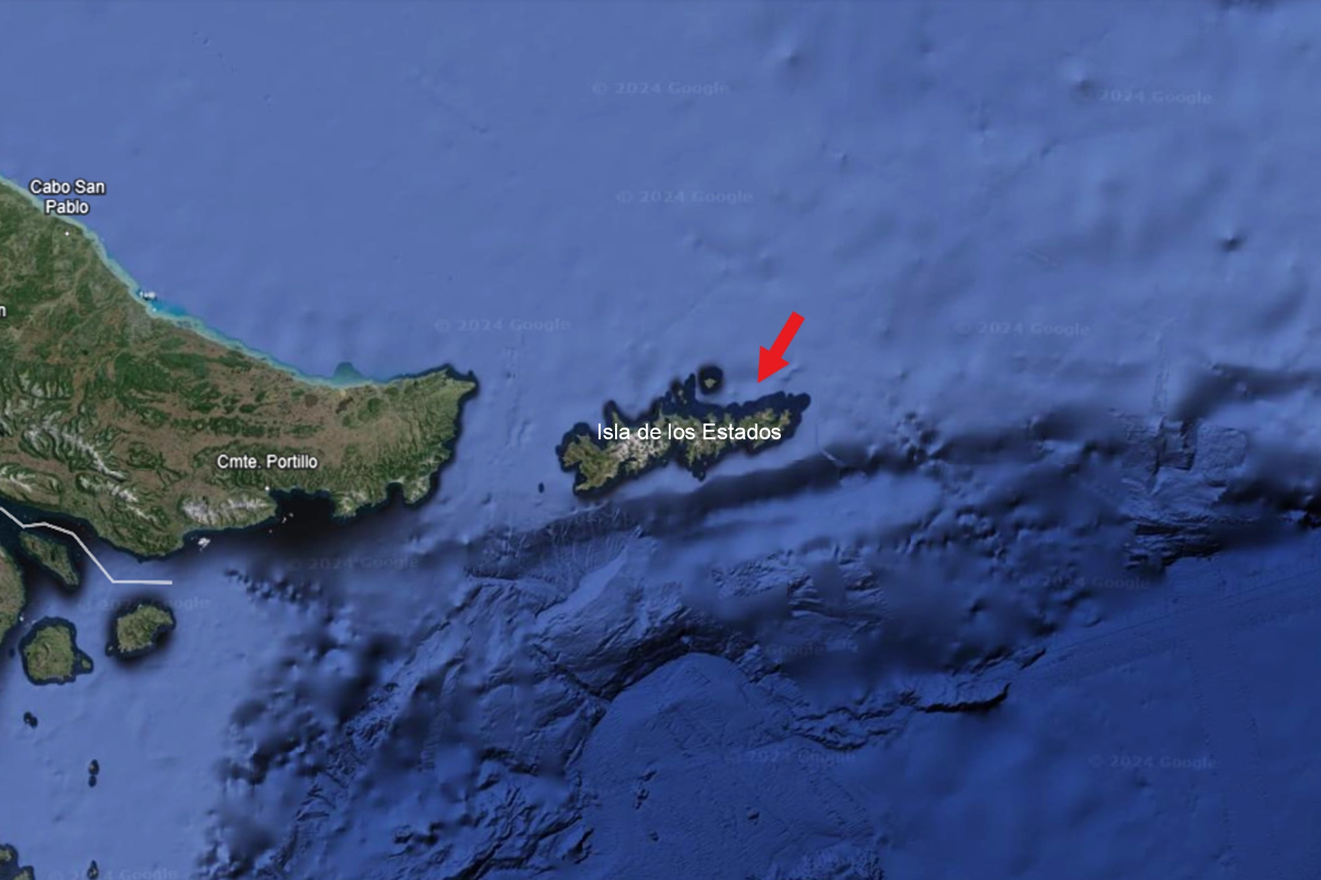
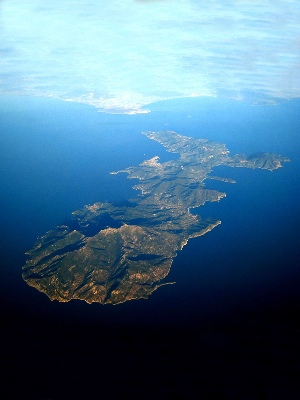
The Provincial Reserve Isla de los Estados is part of the Provincial System of Protected Areas of Tierra del Fuego. It is located to the east of the Fuegian archipelago, between 63° 45′ and 65° West Longitude and between 54° 35′ and 55° South Latitude, separated from the Mitre Peninsula on the Grande Island of Tierra del Fuego by the Le Maire Strait, which is about 16 nautical miles wide. It includes the island of the same name, the Año Nuevo Islands archipelago, and several smaller islands and islets. The total surface area of the islands and islets is 50,736 hectares.

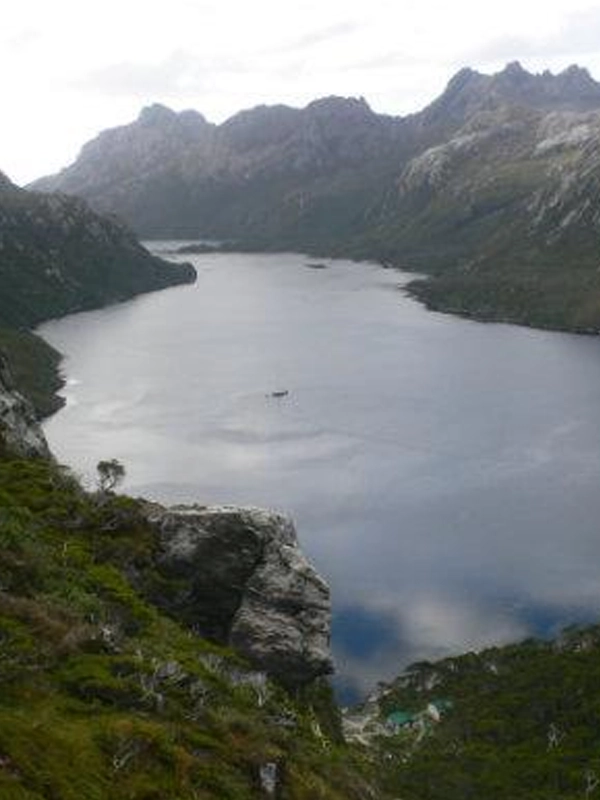
The topography of the island is very varied and includes the last foothills of the Fuegian Andes. Mount Bove, at 823 meters above sea level, is the highest peak. Its coasts feature diverse forms, including numerous rocky cliffs, deep fjords, coves, and bays, where vegetation is abundant and wildlife includes Magellanic penguins, yellow-crested penguins, one and two-haired sea lions, river otters, red deer, introduced goats, elephant seals, and giant petrels on the Año Nuevo Islands, as well as hundreds of marine and terrestrial birds.

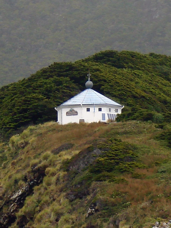
The island has always been a refuge for sailors reaching these latitudes and was the last protected place for those heading to Antarctica. In Punta Lasserre, a lighthouse was erected in 1884, and its replica is still in good condition and can be visited. This is the famous San Juan de Salvamento Lighthouse, also known as the Lighthouse at the End of the World, due to Jules Verne’s novel.

In Puerto Cook, there was a penitentiary that was closed after a massive escape attempt by inmates in 1902. Remnants of the facilities can still be seen.

The island was frequented by seal hunters and fishermen during the 19th and 20th centuries. Remnants of materials can be found in various bays and coves.

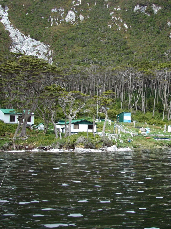
Currently, the Provincial Reserve Isla de los Estados is inhabited by naval personnel from the Piedrabuena Station located in Puerto Parry, the only permanent settlement, which consists of four people.

Discover Isla de los Estados with this sailing expedition through Tierra del Fuego.

This may be one of the purest places on the planet with a rich naval history.

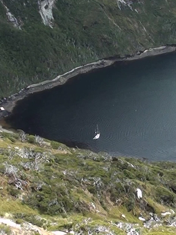
It involves a 350-nautical-mile navigation on a magical journey. We will sail through the Beagle Channel to Puerto Español in Bahía Aguirre, where we will wait for favorable weather conditions and appropriate currents to cross the Le Maire Strait, one of the most challenging in the world. We will then venture into its force and swells until we reach Isla de los Estados.

Conservation Value

The Provincial Reserve Isla de los Estados, or Chuanisin –“land of abundance,” as named by the indigenous peoples– is recognized and appreciated for its lush and unique nature. Additionally, it holds high relevance related to Argentina’s history, Antarctic discoveries and adventures, and the development of navigation and settlement in this portion of the South Atlantic.

Therefore, in recognition of its importance, its status as a protected area, and heritage for all Fueguinos, it was enshrined in the Provincial Constitution, which assigns it special value by establishing in Article 54º: “Declare Isla de los Estados, Año Nuevo Island, and adjacent islets as intangible and permanent heritage of all Fueguinos, ‘Provincial Ecological, Historical, and Touristic Reserve.’”

The conservation value of the reserve is based on both its ecological and historical heritage. Its scenic and landscape importance comes from being the only place in Argentina with fjords. Additionally, along with the coasts of Grande Island of Tierra del Fuego, these are the only sites with coastal-maritime forest formations in the country. Coastal avifauna is one of the most important attributes of the Reserve. It features the two largest colonies of the yellow-crested penguin (Eudyptes chrysocome) recorded in Argentina and the southern giant petrel (Macronectes giganteus), an endangered species. The conservation importance of this area is also due to the presence of critically endangered fauna such as the river otter (Lontra provocax) and the chunchungo (Lontra felina), as well as endemic species like Naussauvia latissima and some species of the Senecio genus (family Asteraceae), and Festuca cirrosa and Poa darwiniana among grasses. Among terrestrial mammals, the guindales mouse (Abrothrix xanthorhinus llanoi) is endemic to the island and the only native mouse recorded.

On the other hand, the Historical Heritage of Isla de los Estados is mainly linked to the remains of penitentiary facilities, the lighthouse, cemeteries (San Juan de Salvamento and Cook), shipwrecks, and a few settlements related to seal hunting and penguin activities.

What It Offers?

Currently, the reserve’s infrastructure includes a permanent prefecture station in Puerto Parry, and during the summer season, a temporary station is added on Isla Observatorio. The extractive use of natural resources is not permitted, but scientific use and regulated, non-mass tourism activities are allowed.

Description

The reserve covers a total area of 50,736 hectares and consists of a large island, Isla de los Estados, and a group of adjacent islands and islets. Isla de los Estados is 63 km long and has a minimum width of 500 meters at the isthmus connecting Puerto Cook with Puerto Vancouver. Its terrain is mountainous, corresponding to the eastern end of the Fuegian Andes. The coasts are very irregular and rugged, forming numerous fjords. The climate is cold, oceanic, and very humid, with annual precipitation approaching 2,000 mm. The winds are very constant, predominantly from the NW and SW. The prevailing vegetation includes evergreen forests of the Southern Beech (Nothofagus betuloides) and Cinnamon Tree (Drimys winterii), with a dense understory of ferns, lichens, and mosses that give it a lush appearance. Other plant communities include grassy bogs and coastal grasslands of Poa flabellata. The marine coastline is notable for extensive brown algae forests that serve as feeding grounds for various bird and marine mammal species.

History

The Yámana people, canoeists who were the first to navigate the dangerous Le Maire Strait in their fragile canoes, called the current reserve Chuanisin, which means «place of abundance.» From the 17th century onward, an extensive list of European navigators explored the bays, coves, and other geographical features of the reserve in search of shelter from storms; but also in search of seal rookeries for the fur trade. Many of these navigators are remembered in the naming of the fjords.

Since 1991, the Nation has declared «Área de los Estados» as Argentina’s first oceanic conservation unit, consisting of the main island and its adjacent islets (National Decree No. 104.169/37). Later, the Constitution of the Province of Tierra del Fuego (Article 54) declared this area as a «Provincial Ecological, Historical, and Touristic Reserve,» an intangible and permanent heritage for all Fueguinos.

In 1998, Provincial Decree No. 2603/98 was issued, establishing a restrictive use regime limited to scientific research. A year later, the National Executive Power enacted Decree 64/99, which declared several sites in the province of Tierra del Fuego as National Historic Monuments and National Historic Sites. Article 3 of this decree designates the Año Nuevo Lighthouse and its residence as a National Historic Monument, and Articles 9 and 10 declare the sites where the San Juan de Salvamento Lighthouse and the Puerto San Juan subprefecture were located as National Historic Sites.

Permits and Authorizations

To visit Isla de los Estados, it is mandatory to obtain authorization and permits from the Government of Tierra del Fuego. Required data and elements to process entry into the Provincial Reserve Isla de los Estados:

  • Communicate with [email protected]
  • From the applicant: full name, DNI/passport (scanned image), nationality, address, phone number, email address.
  • From the vessel: Certificate of registration (scanned image).
  • From the trip: a letter addressed to the General Directorate of Biodiversity and Conservation (signature, clarification, place, and date) stating the reason, interest, and objectives, itinerary and tentative schedule, contact details of at least one person on land for possible communication during the trip (in PDF format).
  • From the group members: full names, DNI/passport, nationality.
  • Familiarize yourself with the content of Provincial Decree No. 584/15 (Tourism Opening RPIE).
  • In the case of tourism service providers and companies, present the documentation requested under Provincial Decree No. 584/15 (Tourism Opening RPIE).
  • Know and adhere to any specific guidelines that may be established for each particular trip.
Discover Sailing to the Majestic Isla de Los Estados with the Ksar Sailboat Embark on an unforgettable voyage to the Isla de Los Estados with the Ksar Sailboat in Tierra del Fuego. Departing from Ushuaia, this journey takes you to a remote and pristine destination, offering a unique experience in Patagonia, Argentina. Explore the unspoiled nature and stunning landscapes of this extraordinary place. The Reserva Provincial Isla de Los Estados is part of the Provincial System of Protected Areas in Tierra del Fuego. Located to the east of the Fuegian archipelago, between 63° 45' and 65° West Longitude and 54° 35' and 55° South Latitude, it is separated from the Mitre Peninsula by the Le Maire Strait, approximately 16 nautical miles wide. This reserve encompasses the main island, the Año Nuevo Archipelago, and several smaller islands and islets, covering a total area of 50,736 hectares. The island's topography is diverse, featuring the final ranges of the Fuegian Cordillera. The highest peak is Mount Bove, standing at 823 meters above sea level. The coastlines are rugged, with numerous cliffs, deep fjords, inlets, and bays, abundant in vegetation and wildlife. The island is home to a variety of species, including Magellanic and yellow-eyed penguins, sea lions, huillines (otters), red deer, introduced goats, elephant seals, and giant petrels on Año Nuevo Island. It also hosts hundreds of marine and terrestrial bird species. Historically, the island served as a refuge for navigators reaching these latitudes and was the last protected haven for those heading to Antarctica. In 1884, a lighthouse was erected at Punta Lasserre, which still stands today as a replica of the famous San Juan de Salvamento Lighthouse, also known as the Lighthouse at the End of the World, popularized by Jules Verne's novel. Puerto Cook once housed a prison, which was closed in 1902 after a mass escape attempt. Remnants of the prison's facilities can still be seen. The island was frequented by seal hunters and fishermen during the 19th and 20th centuries, with remnants of their activities found in various bays and inlets. Today, the Reserva Provincial Isla de Los Estados is inhabited by naval personnel from the Apostadero Piedrabuena, based in Puerto Parry, the only permanent settlement with four residents. Experience Isla de Los Estados on this sailboat expedition through Tierra del Fuego. This destination, one of the purest places on the planet with a rich naval history, offers a 350-nautical-mile magical journey. Navigate the Beagle Channel to Puerto Español in Bahía Aguirre, waiting for favorable weather and currents to cross the challenging Le Maire Strait, reaching Isla de Los Estados. Conservation Value The Reserva Provincial Isla de Los Estados, or Chuanisin—"land of abundance," as named by the indigenous peoples—is highly valued for its unique and lush nature. It also holds significant importance for Argentina's history, Antarctic exploration, and the development of navigation and settlement in the South Atlantic. Its protected status and the special value assigned to it by the Provincial Constitution (Article 54º) declare it a "Provincial Ecological, Historical, and Tourist Reserve," a permanent heritage of all Fuegians. The conservation value of the reserve is based on its ecological and historical heritage. It is the only place in Argentina with fjords and along with the coastlines of Isla Grande de Tierra del Fuego, features unique coastal forest formations. The coastal avifauna is particularly notable, with the largest colonies of yellow-eyed penguins and southern giant petrels in Argentina. The reserve also hosts critically endangered species like the huillín and chuchungo, as well as endemic plant species. What It Offers Currently, the reserve's infrastructure includes a permanent coast guard station in Puerto Parry and a temporary station in Isla Observatorio during the summer. The use of natural resources is restricted to scientific research and regulated tourism. Description The reserve covers 50,736 hectares, including Isla de Los Estados and nearby islands and islets. Isla de Los Estados is 63 km long and at its narrowest point, 500 meters wide, featuring a mountainous relief. The coastlines are highly irregular, forming numerous fjords. The climate is cold, oceanic, and very humid, with annual precipitation near 2,000 mm and prevailing winds from the northwest and southwest. Vegetation includes evergreen forests of ñire and canelo, dense undergrowth of ferns, lichens, and mosses, and coastal grasses. The marine coast is characterized by extensive kelp forests that support diverse marine and bird species. History The Yámana people, the first to navigate the dangerous Le Maire Strait in their fragile canoes, named the reserve Chuanisin, meaning "place of abundance." Since the 17th century, European navigators have explored the reserve’s bays and inlets seeking refuge and hunting seals. Many navigators' names are memorialized in the fjords' names. In 1991, Argentina's National Government designated "Área de los Estados" as the country's first oceanic conservation unit (National Decree No. 104.169/37). Later, the Tierra del Fuego Province Constitution declared it a "Provincial Ecological, Historical, and Tourist Reserve" (Article 54). In 1998, Provincial Decree No. 2603/98 established restrictive usage regulations for scientific research, and the National Executive issued Decree 64/99, designating several sites in Tierra del Fuego as National Historic Monuments and Places. Permits and Authorizations To visit Isla de Los Estados, authorization and permits from the Government of Tierra del Fuego are required. Contact areasprotegidas@tierradelfuego.gob.ar with the following details: Applicant's full name, DNI/passport (scanned image), nationality, address, phone, email. Vessel details: Certificate of registration (scanned image). Trip details: Letter to the General Directorate of Biodiversity and Conservation (signed, dated) stating the purpose, interest, objectives, itinerary, and contact information for someone on land during the trip (in PDF format). Group members' names, DNI/passport, nationality. Familiarize yourself with Provincial Decree No. 584/15 (Tourism Opening RPIE). Service providers must present additional documentation as required by this decree. Explore Isla de Los Estados with this sailboat expedition and immerse yourself in one of the world's most pristine and historically rich locations.

YOU ARE READY?

u

Ask us

Don’t be left wondering what it’s like to travel on the Ksar Sailboat.

BOOKING

Book your trip in advance, so as not to be left out of season.

Browse

All ready! We are waiting for you to venture on the Ksar Sailboat expeditions.

Fulfill your dreams

DESTINATIONS IN BEAGLE CHANNEL

Sailing on a Ksar Sailboat to the States Island!